Gridics parcel-specific zoning data is available in different levels of data access. Each data tier has a different cost associated with it because of the level of detail provided. These tiers are meant to service different use cases as we understand not everyone will need the same level of detail as others.
If you have questions about our service level agreements, please Contact Us for more details.
Pricing Summary:
| Summary of fields | Basic $0.29/call | Enhanced $0.49/call | Premium $0.69/call |
|---|---|---|---|
| Address | x | x | x |
| Zone | x | x | x |
| Stated Zone Attributes (FAR, Lot Area, Max Height, etc) | x | x | x |
| Overlays (*where available) | x | x | |
| Uses | x | x | |
| Lot Type (Corner, Block, Internal, etc) | x | ||
| Calculated Parcel-specific Buildable Capacity (Setbacks, Max Buildable Area, Units Allowed, etc) | x | ||
| Frontages | x | ||
| Geometry | x | ||
| - Base Footprint and Floors | x | ||
| - Base Footprint with Setbacks and Floors with Setbacks | x | ||
| - Building Envelope | x |
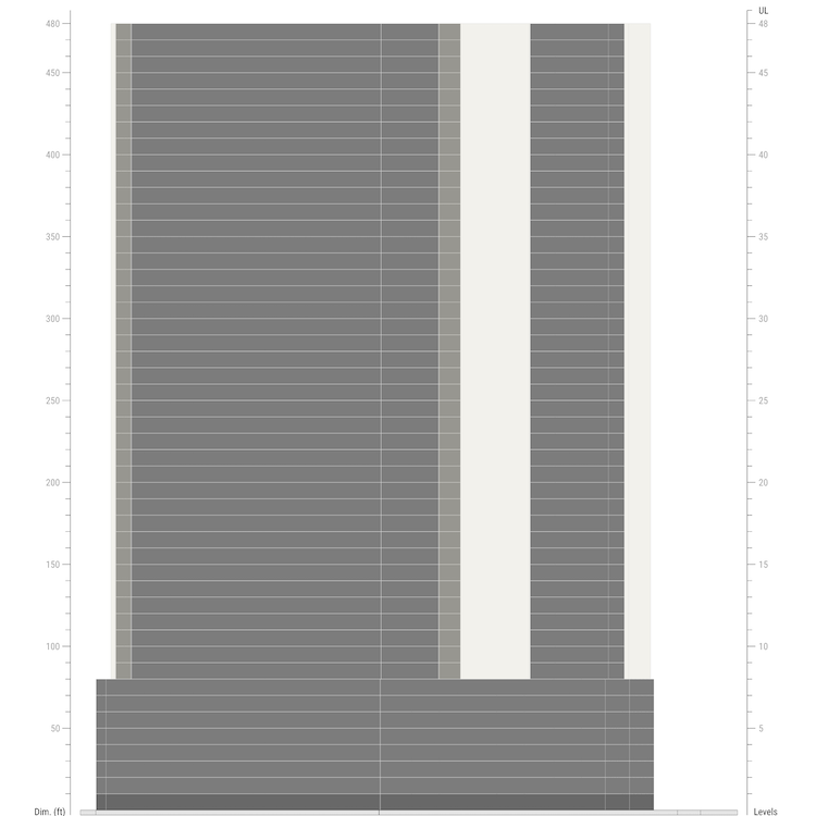
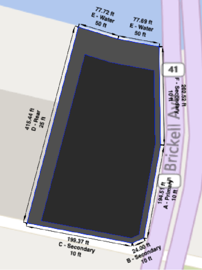
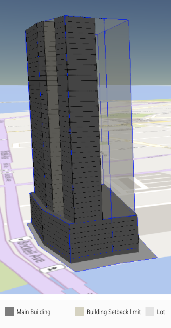
Geometry provides developers with the ability to construct building details on a map. Below are examples of how these features are used within Gridics' internal applications.
- Base Footprint and Floors

- Base Footprint with Setbacks and Floors with Setbacks

- Building Envelope

Specific Data Points By Product Access
NOTE: Not every field is populated in every market but these are all fields that could be present.
| Object | Alias / Title | Basic $0.29/call | Enhanced $0.49/call | Premium $0.69/call |
|---|---|---|---|---|
| Id | ID | x | x | x |
| GroupId | GroupID | x | x | x |
| Address | Address | x | x | x |
| City | State | x | x | x |
| State | City | x | x | x |
| ZipCode | ZipCode | x | x | x |
| FolioNumber | Parcel ID | x | x | x |
| LotType | Lot Type | x | ||
| CalculationStatus | Calculation Status | x | x | x |
| updatedAt | Last Updated | x | x | x |
| Buildings[*].Views.ZA.lot | (Geometry) | x | ||
| Buildings[*].Views.ZA.floorsArrays.all | (Geometry) | x | ||
| Buildings[*].Views.ZA.floorsArrays.setbacks | (Geometry) | x | ||
| Buildings[*].GeoJSONViews | (Geometry) | x | ||
| Buildings[*].Overlays[*].Id | Overlay ID | x | x | |
| Buildings[*].Overlays[*].Name | Overlay Name | x | x | |
| Buildings[*].Overlays[*].Description | Overlay Description | x | x | |
| Buildings[*].Overlays[*].CalibrationType | Overlay Type | x | x | |
| Buildings[*].Overlays[*].GridicsId | x | x | ||
| Buildings[*].Overlays[*].Attributes[*].Id | Overlay Attribute ID | x | x | |
| Buildings[*].Overlays[*].Attributes[*].AttributeType | Overlay Attribute Type | x | x | |
| Buildings[*].Overlays[*].Attributes[*].AttributeValue | Overlay Attribute | x | x | |
| Buildings[*].Overlays[*].Attributes[*].Description | Overlay Attribute Description | x | x | |
| Buildings[*].Overlays[*].Attributes[*].IsEnabled | x | x | ||
| Buildings[*].Uses | x | x | ||
| Buildings[*].Envelope.AreaAllowedByFloorplate | Form Maximum Buildable Area | x | ||
| Buildings[*].Envelope.DensityNet | Residential Density | x | x | x |
| Buildings[*].Envelope.DensityUnits | Maximum Residential Units | x | ||
| Buildings[*].Envelope.FloorAreaRatio | Floor Area Ratio | x | x | x |
| Buildings[*].Envelope.FloorAreaRatioCapacity | Floor Area Ratio Maximum Buildable Area | x | x | x |
| Buildings[*].Envelope.LodgingCapacity | Maximum Lodging Rooms | x | ||
| Buildings[*].Envelope.LotAreaAcres | Simplified Parcel shape Area - Acres | x | x | x |
| Buildings[*].Envelope.LotAreaFeet | Simplified Parcel Shape Area - Square Feet | x | x | x |
| Buildings[*].Envelope.LotAreaPR | Parcel Area - Tax Record | x | x | x |
| Buildings[*].Envelope.LotAreaFeetGAPI | Parcel Area - GIS | x | x | x |
| Buildings[*].Envelope.LotCoverage | Maximum Building Coverage Percentage | x | x | x |
| Buildings[*].Envelope.MaxBonusHeightAllowed | Maximum Bonus Stories (Deprecated) | x | x | x |
| Buildings[*].Envelope.MaxBuildingAreaAllowed | Maximum Buildable Area | x | x | x |
| Buildings[*].Envelope.MaxBuildingFootprint | Maximum Building Footprint | x | x | x |
| Buildings[*].Envelope.MaxCommercialAreaAllowed | Maximum Commercial Use Allowed | x | ||
| Buildings[*].Envelope.MaxCommercialEstablishedArea | Maximum Individual Commercial Space | x | x | x |
| Buildings[*].Envelope.MaxCommercialHeightAllowed | Maximum Commercial Stories | x | x | x |
| Buildings[*].Envelope.MaxLotCoverageArea | Maximum Building Footprint - From Percentage | x | ||
| Buildings[*].Envelope.MaxOfficeAreaAllowed | Maximum Office Use Allowed | x | ||
| Buildings[*].Envelope.MaxOfficeCommercialAllowed | Maximum Office/Commercial Uses Allowed | x | x | x |
| Buildings[*].Envelope.MaxOfficeHeightAllowed | Maximum Office Stories | x | x | x |
| Buildings[*].Envelope.MaxTowersNumber | Maximum Tower Stories | x | x | x |
| Buildings[*].Envelope.MinOpenSpace | Minimum Open Space Percentage | x | x | x |
| Buildings[*].Envelope.MinOpenSpaceSquareFeet | Minimum Open Space | x | ||
| Buildings[*].Envelope.PodiumArea | Main Structure Area (Form) | x | ||
| Buildings[*].Envelope.PrincipalMaxHeight | Maximum Podium Stories | x | ||
| Buildings[*].Envelope.PrincipalMinHeight | Minimum Podium Stories Required | x | x | x |
| Buildings[*].Envelope.PrincipalPenthouseHeight | Maximum Penthouse Height | x | ||
| Buildings[*].Envelope.PrincipalTowerHeight | Maximum Tower Height | x | ||
| Buildings[*].Envelope.SecondLayerDimension | Liner Building Minimum Depth | x | x | x |
| Buildings[*].Envelope.TotalBuidingHeight | Maximum Building Height | x | x | x |
| Buildings[*].Envelope.TowerArea | Maximum Tower Area | x | ||
| Buildings[*].Envelope.TowerBonusMaxHeight | Maximum Bonus Stories | x | x | x |
| Buildings[*].Envelope.TowerMaxArea | Maximum Tower Footprint | x | ||
| Buildings[*].Envelope.TowerMaxAreaActual | Maximum Tower Footprint Possible | x | x | x |
| Buildings[*].Envelope.LodgingCapacityCalculated | Maximum Lodging Rooms Allowed | x | x | x |
| Buildings[*].Envelope.MaximumResidentialBuildableArea | Maximum Residential Uses Allowed | x | ||
| Buildings[*].Envelope.MaximumLodgingBuildableArea | Maximum Lodging Uses Allowed | x | ||
| Buildings[*].Envelope.EffectivePFrontSetbackPrincipal | Minimum Podium Primary Front Setback | x | ||
| Buildings[*].Envelope.EffectivePFrontSetbackSecondary | Minimum Podium Secondary Front Setback | x | ||
| Buildings[*].Envelope.EffectivePRearSetback | Minimum Podium Rear Setback | x | ||
| Buildings[*].Envelope.EffectivePSideSetback | Minimum Podium Side Setback | x | ||
| Buildings[*].Envelope.EffectivePWaterSetback | Minimum Podium Waterfront Setback | x | ||
| Buildings[*].Envelope.EffectiveTFrontSetbackPrincipal | Minimum Tower Primary Front Setback | x | ||
| Buildings[*].Envelope.EffectiveTFrontSetbackSecondary | Minimum Tower Secondary Front Setback | x | ||
| Buildings[*].Envelope.EffectiveTRearSetback | Minimum Tower Rear Setback | x | ||
| Buildings[*].Envelope.EffectiveTSideSetback | Minimum Tower Side Setback | x | ||
| Buildings[*].Envelope.EffectiveTWaterSetback | Minimum Tower Waterfront Setback | x | ||
| Buildings[*].Envelope.EffectivePeFrontSetbackPrincipal | Minimum Penthouse Primary Front Setback | x | ||
| Buildings[*].Envelope.EffectivePeFrontSetbackSecondary | Minimum Penthouse Secondary Front Setback | x | ||
| Buildings[*].Envelope.EffectivePeRearSetback | Minimum Penthouse Rear Setback | x | ||
| Buildings[*].Envelope.EffectivePeSideSetback | Minimum Penthouse Side Setback | x | ||
| Buildings[*].Envelope.MaxIndustrialAreaAllowed | Maximum Industrial Uses Allowed | x | ||
| Buildings[*].Envelope.MaxCivicAreaAllowed | Maximum Civic Uses Allowed | x | ||
| Buildings[*].Envelope.MaxCivicSupportAreaAllowed | Maximum Civic Support Uses Allowed | x | ||
| Buildings[*].Envelope.MaxEducationalAreaAllowed | Maximum Educational Uses Allowed | x | ||
| Buildings[*].Envelope.DensityUL | Unlimited Residential Density | x | x | x |
| Buildings[*].Envelope.LodgingDensityUL | Unlimited Lodging Density | x | x | x |
| Buildings[*].ZoningAllowance.ZoningCodeId | Gridics Calibrated Zoning Code | x | x | x |
| Buildings[*].ZoningAllowance.ZoneId | Primary Zone | x | x | x |
| Buildings[*].ZoningAllowance.SubZoneId | Sub Zone | x | x | x |
| Buildings[*].ZoningAllowance.ZoneTypeId | Zone Type | x | x | x |
| Buildings[*].ZoningAllowance.BuildingTypologyId | Building Typology | x | x | x |
| Buildings[*].ZoningAllowance.ZoningRegulationName | Zone Regulation Name | x | x | x |
| Buildings[*].ZoningAllowance.ZoneCombinationName | Zone | x | x | x |
| Buildings[*].CalibrationGeneral.PFrontSetbackPrincipalMax | Maximum Principal Frontage Setback (Podium) | x | x | x |
| Buildings[*].CalibrationGeneral.PFrontSetbackSecondaryMax | Maximum Secondary Frontage Setback (Podium) | x | x | x |
| Buildings[*].CalibrationGeneral.PSideSetbackMax | Maximum Side Setback (Podium) | x | x | x |
| Buildings[*].CalibrationGeneral.PRearSetbackMax | Maximum Rear Setback (Podium) | x | x | x |
| Buildings[*].Frontages[*].Label | Polygon segment Label | x | x | |
| Buildings[*].Frontages[*].FrontageType | Frontage Types | x | x | |
| Buildings[*].Frontages[*].Setback | Building setback for specific frontage | x | x | |
| Buildings[*].Frontages[*].MinThoroughfareWidth | Right-of-Way width | x | x | |
| Buildings[*].Frontages[*].SegmentsLengths | Frontage dimension | x | x | |
| Buildings[*].UsesStatistic | Allowed Use Statistics | x | x |